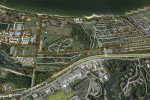
GEOGRAPHIC INFORMATION SYSTEMS (GIS) SURVEYS
Gordon provides GIS support to municipal, state, and government entities to assist in the development of new GIS databases or updates to existing records. Services that support GIS include utility mapping and cemetery headstone location surveys. Additionally, Gordon engineers utilize survey data for Civil Information Modeling (CIM) to create a working model that is transferred to facility owners with record documentation.
 Patuxent River Naval Air Station - St. Mary's County, MD, NAVFAC Facilities GIS